

Reading a Himalayan Skyline: How to Identify Peaks
यो कथा अहिलेलाई अङ्ग्रेजीमा मात्र उपलब्ध छ।
A shape-position-neighbours method for naming Himalayan peaks on sight, plus six annotated panoramas from Nepal's best viewpoints.
NepGem टोली · स्थानीय गाइड र यात्रा योजनाकार
· ११ मिनेट पढाइ

 [GEN]
Every trekker standing on a Himalayan ridge asks the same question at some point: which one is Everest? The honest answer is that you cannot always tell by height alone, because the mountain that looks biggest from the trail is often not the tallest one on the horizon. Nuptse, at 7,861 m, routinely upstages Everest's 8,848.86 m summit from below because it stands closer to the viewer and blocks the taller peak behind it. Identifying a Himalayan skyline is a skill built from three things — shape, position and neighbours — not a matter of memorising how tall Everest actually is and expecting the tallest-looking shape to match the number. This article gives you that method, then applies it to six of Nepal's best viewpoints so you can check your reading against a described panorama before you ever leave home.
The method: shape, position, neighbours
Naming a peak from a trail comes down to reading three signals together, and no single one is reliable on its own. Shape narrows the candidates, position confirms the direction, and a known neighbour anchors the whole picture.
Shape is the fastest filter. A handful of Himalayan peaks have silhouettes distinctive enough to name from shape alone, even in poor light. Machhapuchhre's twin summit, split by a narrow ridge into what looks like a fish's tail, is unmistakable from the Annapurna region and gives the mountain its English name, "Fishtail". Ama Dablam carries a hanging glacier on its south-west face that locals and climbers alike call "the pendant", a bulging ice mass tucked below the summit ridge that no other Khumbu peak wears in quite the same way. Everest itself, seen from a distance, is a blunt pyramid with a distinctive black rock band near the summit where snow cannot hold on the steep face — the summit is usually the least dramatic-looking point on a crowded skyline, not the most.
Position matters more than shape for peaks without a signature silhouette. Work out which direction you are facing using the sun's position or a compass, then use a map or a peak-identification chart to establish which named summits should lie along that bearing. A peak sitting due north of Namche Bazaar on a Khumbu itinerary is a very different candidate than one bearing north-east, even if the two look similar in profile.
Neighbours is the method that actually resolves ambiguous cases. Once you have confidently identified one peak — usually the closest, most famous, or most clearly labelled one on a printed panorama — every other peak's position relative to it becomes a measurement rather than a guess. If you know Everest's black pyramid sits behind and slightly right of Nuptse's flatter ridge from Kala Patthar, you have effectively identified both peaks from one fixed point. This is also the technique local guides use, and it works better than a phone app in poor signal or battery-cold conditions above 4,000 m.
One distortion trips up almost every first-time trekker before they learn to correct for it: apparent size has almost nothing to do with actual height once distance enters the picture. A 7,000 m peak two kilometres away will dominate the frame over an 8,000 m peak fifteen kilometres further back, simply because it occupies more of your field of view. Foreshortening compresses distant ridgelines together, so two peaks separated by several kilometres on a map can appear to be sitting almost on top of one another from a single viewpoint. Correcting for this mentally — reminding yourself that "biggest in view" and "tallest in the world" are unrelated claims — is the single habit that stops most misidentifications before shape or position even come into it.
Six annotated panoramas
These six viewpoints cover Nepal's most-photographed mountain panoramas, from a 3,210 m foothill to a 5,644 m Khumbu summit. Each description below matches the annotated graphic that accompanies it, so you can cross-check a live view against a described one.
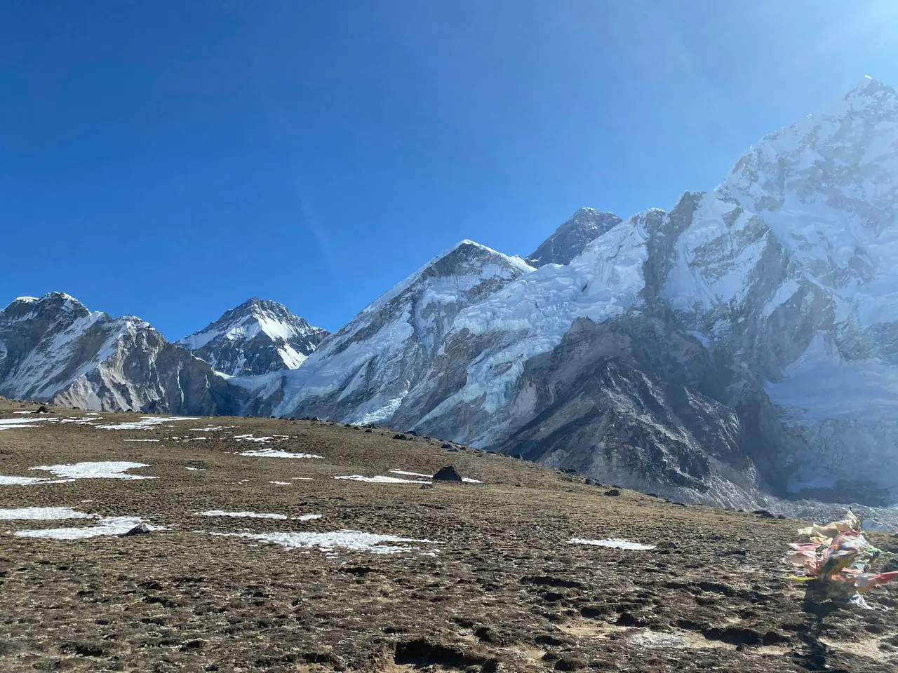
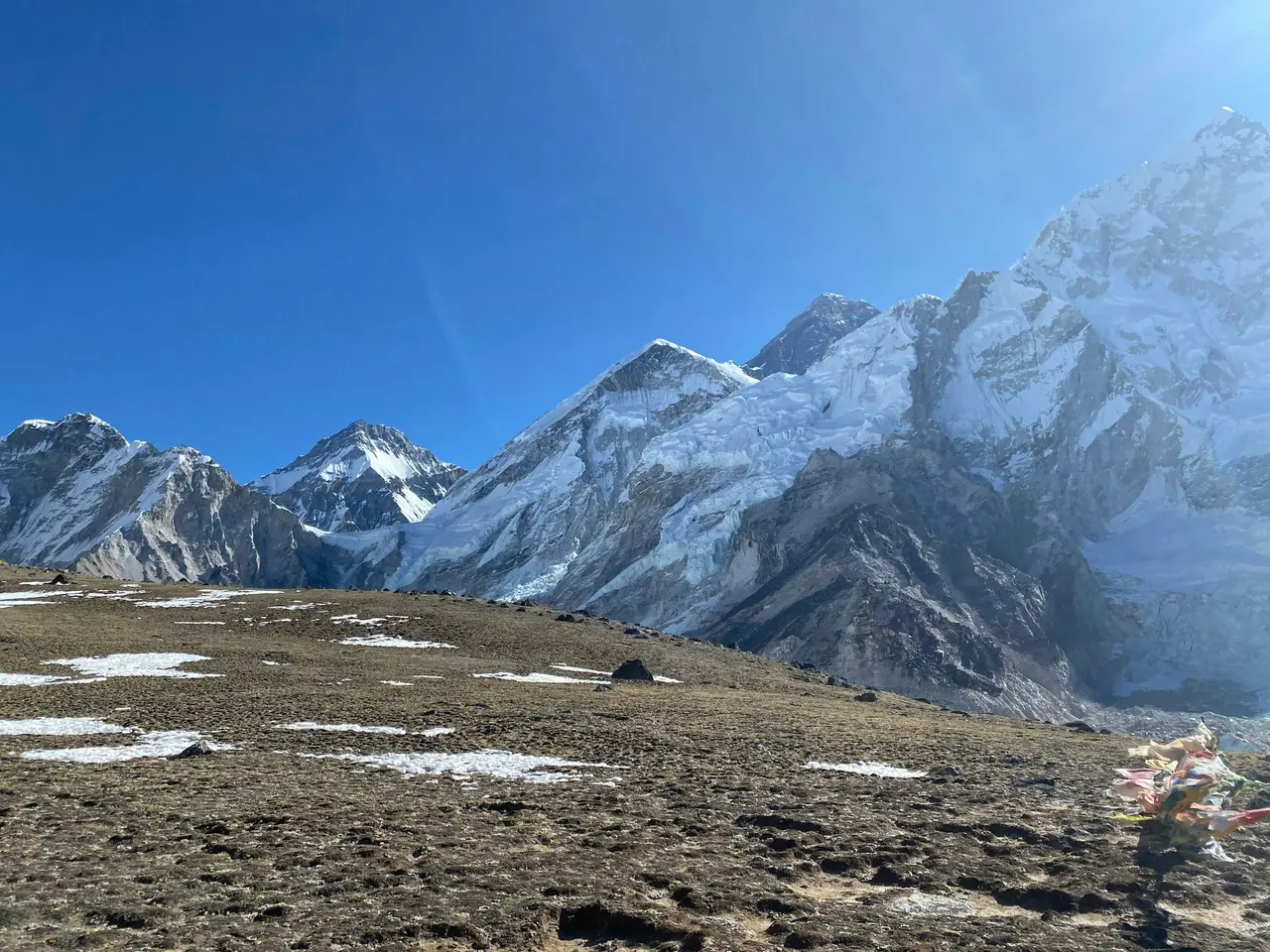
Kala Patthar (5,644 m). The classic Everest Base Camp trek finale, and the viewpoint most travellers mean when they say they want to "see Everest". Facing roughly north-east from the summit cairn, Everest's black pyramid sits centre-frame, partly obscured by Nuptse's long ridge in the foreground and flanked on the right by Lhotse's 8,516 m wall. Pumori, at 7,161 m, rises sharply to the west and is often mistaken for a higher peak because of its symmetrical pyramid shape and closer distance to the viewpoint.
Gokyo Ri (5,357 m). The Gokyo valley's answer to Kala Patthar, and arguably a better single-frame panorama because it includes four eight-thousanders in one sweep on a clear day: Everest and Lhotse to the east, Makalu's distant pyramid further east again, and Cho Oyu's broad 8,188 m massif dominating the north-west skyline above the Ngozumpa glacier, Nepal's longest. The turquoise Gokyo lakes sitting directly below the summit give this panorama a foreground layer none of the other five viewpoints on this list can match, which is part of why it photographs so differently from Kala Patthar despite similar peaks appearing in both frames.
Poon Hill (3,210 m). The Annapurna region's sunrise viewpoint delivers the widest low-altitude panorama on this list without requiring more than a short pre-dawn walk from Ghorepani. Dhaulagiri's 8,167 m massif anchors the western end of the skyline, Annapurna I at 8,091 m and Annapurna South at 7,219 m sit centre-frame, and Machhapuchhre's fishtail summit stands slightly apart to the east, closer and therefore visually larger than its 6,993 m height would suggest. Two of Nepal's eight 8,000 m peaks are visible from this single sunrise stop, which is a large part of why Poon Hill remains one of the most-climbed viewpoints in the country despite its modest 3,210 m elevation.
Sarangkot (~1,600 m). Pokhara's hillside viewpoint puts the entire Annapurna Sanctuary skyline within reach of a short taxi ride and no trekking at all. Machhapuchhre dominates directly north, with Annapurna South and, on the clearest days, the Dhaulagiri massif visible further west. Sarangkot's low altitude means haze cuts visibility more often than at higher viewpoints, so early morning is essential, and the same low elevation is why a viewpoint this close to a city can still deliver a genuine eight-thousander skyline.
Nagarkot (~2,175 m). East of Kathmandu Valley, Nagarkot's sunrise terraces trade a single dramatic massif for genuine breadth: the Langtang range including 7,227 m Langtang Lirung to the north, Ganesh Himal's 7,422 m ridge further west, and on exceptionally clear winter mornings a distant sliver of the Everest massif over 140 km away — small enough on the horizon that most visitors need a guide's pointing finger to find it.
Pikey Peak (4,065 m). A lower-traffic viewpoint east of the Everest region, often cited in trekking circles for offering one of the widest unobstructed Everest panoramas of any easily reached summit, without the crowds or altitude risk of Kala Patthar. The Everest massif appears at genuine distance alongside Makalu and the Rolwaling range, giving a sense of relative scale that closer viewpoints cannot. Because Pikey sits roughly 60 km south-east of Everest rather than directly beneath it, the whole Khumbu skyline reads as a single connected range rather than a handful of individually towering summits — the clearest illustration on this list of how distance changes what a mountain looks like, detailed further in the trek itself.
The peaks people always misname
Three misidentifications happen so often on Nepal's trails that experienced guides anticipate the question before it is asked. Knowing them in advance saves an argument with a fellow trekker at 5,000 m.
Nuptse for Everest. This is the single most common error in the Khumbu. Nuptse's 7,861 m summit sits directly in front of Everest from most of the standard trail, including much of the walk into Everest Base Camp itself, and its broad ridge genuinely looks larger and more imposing than Everest's true summit pyramid, which is set back and often part-hidden. The giveaway is the black rock band: Everest's summit shows a distinctive dark band near the top where wind strips snow off exposed rock, a feature Nuptse's more rounded profile does not share in the same way.
Machhapuchhre for Annapurna. From Pokhara and most Annapurna-region viewpoints, Machhapuchhre's fishtail silhouette is the closest, most dramatic peak in view, and travellers who have heard of "Annapurna" as the region's headline name often assume the nearest dramatic mountain must be it. Annapurna I, at 8,091 m, is the range's true high point and sits further back and further west, a broader, less theatrically shaped massif that photographs less memorably than its smaller neighbour.
Thamserku for Ama Dablam. Both peaks rise dramatically above the Khumbu trail between Namche Bazaar and Tengboche, and both have striking, non-pyramidal profiles that stand out from the surrounding ridgelines. Thamserku, at 6,623 m, sits closer to the trail near Namche and is often the first dramatic peak trekkers photograph, later mislabelling it as Ama Dablam once they learn that name from a guidebook. Ama Dablam's genuine identifier is the hanging glacier "pendant" below its summit ridge, a feature Thamserku's face does not carry.
Apps vs. eyes
A peak-identification app such as PeakFinder or PeakVisor is a useful cross-check, not a substitute for the shape-position-neighbours method, and Himalayan conditions expose the gap between the two more than most mountain ranges do. These apps use your phone's GPS and compass to overlay named summits on a live camera view, which works well at lower altitude with a strong signal and a warm battery.
Above roughly 4,000 m, three things degrade app reliability at exactly the moment you most want it to work. Cold drains lithium-ion batteries fast enough that a fully charged phone can shut down within an hour of exposure. GPS fixes can drift in narrow Himalayan valleys where satellite geometry is poor between high ridgelines. And most of these apps assume a data connection or a pre-downloaded offline map for the correct region, which many trekkers forget to load before losing signal beyond the last village with a mobile tower.
The shape-position-neighbours method costs nothing, needs no battery, and improves with practice in a way an app reading never will. Use an app as a first pass at an unfamiliar viewpoint if you have one working, then confirm what it tells you against the peak's actual shape and its position relative to a mountain you already know. A guide who has led the same route dozens of times will usually beat both methods by simply having stood at that exact cairn before and remembering the skyline from memory.
FAQ
Which mountain looks like Everest but isn't? Nuptse, at 7,861 m, is the mountain most often mistaken for Everest. It stands directly in front of Everest along most of the Khumbu trail, including near Everest Base Camp, and its broad ridge appears larger from below than Everest's true, more distant summit pyramid, which is often part-hidden behind it.
How do I identify peaks in Nepal? Use three signals together: the peak's shape (a fishtail summit, a hanging glacier, a black rock band near the top), its compass position relative to your known location, and its position next to a peak you can already confidently name. No single signal is reliable alone, but the three combined resolve almost any Himalayan skyline.
Can you see Everest from Pokhara? No. Pokhara and its viewpoints such as Sarangkot look onto the Annapurna and Dhaulagiri massifs, which lie roughly 150 km west of Everest. The two mountain groups are not visible from the same viewpoint; you need to be in the Khumbu, Solu, or an easterly high viewpoint such as Nagarkot or Pikey Peak to see Everest itself.
What is the fish-tail mountain? The fish-tail mountain is Machhapuchhre, a 6,993 m peak in the Annapurna region whose summit is split by a narrow ridge into two points resembling a fish's tail when viewed from Pokhara or the Annapurna Sanctuary trail. It is considered sacred in local Gurung tradition and has never been officially summited.
A guide who can name every peak on the skyline before you ask
Reading a panorama from a description is useful preparation; standing on the actual ridge with someone who has crossed it dozens of times is a different level of confidence entirely. NepGem's guide profiles show each guide's altitude record and the specific routes they have led repeatedly, so you can see, before you book, whether the person leading you to Kala Patthar or Poon Hill has genuinely stood at that cairn before rather than reading the same panorama chart you have. Hire the guide directly, see their licence and route history up front, and you get a running commentary on the skyline that no app or annotated photograph can match — the kind of detail, like which ridge hides Everest's true summit from which exact step on the trail, that only comes from repetition.


