

Nepal's Glaciers and Glacial Lakes
यो कथा अहिलेलाई अङ्ग्रेजीमा मात्र उपलब्ध छ।
The Khumbu glacier trekkers walk across, the mechanism behind a glacial lake outburst flood, and which of Nepal's monitored lakes carry real risk.
NepGem टोली · स्थानीय गाइड र यात्रा योजनाकार
· १२ मिनेट पढाइ

 [PHOTO]
Nepal is home to several thousand glaciers, and a meaningful number of the lakes forming at their edges are considered dangerous enough to be actively monitored for the risk of a sudden, catastrophic flood. Anyone walking the Everest Base Camp trail spends several days on or beside one of these glaciers without necessarily realising it, because a large, debris-covered Himalayan glacier looks more like a boulder field than the clean white ice most travellers picture. This article covers what is actually melting, how a glacial lake outburst flood happens, which specific Nepali lakes carry documented risk, and what a trekker can and cannot see of any of it from the trail.
Nepal's ice, in numbers
Nepal contains several thousand glaciers, collectively covering an estimated 3,900 km² of the country's high-mountain terrain, concentrated overwhelmingly in the Everest (Khumbu), Annapurna, Langtang and Kanchenjunga regions where elevation and precipitation combine to sustain permanent ice. These glaciers range from small, high-altitude cirque glaciers a few hundred metres long to major valley glaciers many kilometres in length that have shaped the U-shaped valleys trekkers walk through today.
Alongside the glaciers themselves, Nepal has several hundred glacial lakes, water bodies formed where meltwater collects behind a natural dam of glacial debris (moraine) rather than solid bedrock. A subset of these lakes, numbering in the dozens, are classified by researchers and government agencies as carrying a meaningful risk of sudden, dangerous drainage, because the moraine dams holding them back are not built to withstand the water pressure or physical shock that an unstable, growing lake can eventually deliver. How the Himalaya formed explains why this terrain produces glaciers and unstable moraine in the first place: young, still-rising rock combined with heavy monsoon-fed snowfall at altitude creates exactly the conditions glaciers need to form and, eventually, the loose debris that dams the lakes they leave behind.
Most of this ice sits above 5,000 m, in accumulation zones where snowfall exceeds melt for most of the year, before flowing slowly downhill under its own weight into lower ablation zones where melt dominates and the glacier's surface lowers and retreats. This basic accumulation-versus-ablation balance, not simply "hot weather", is the mechanism that determines whether a given glacier is stable, growing or retreating in any particular year, and it is the same balance that governs the meltwater supply feeding rivers such as the Dudh Koshi and Marsyangdi that trekking routes and lodges depend on downstream.
The Khumbu glacier, and walking on a dying one
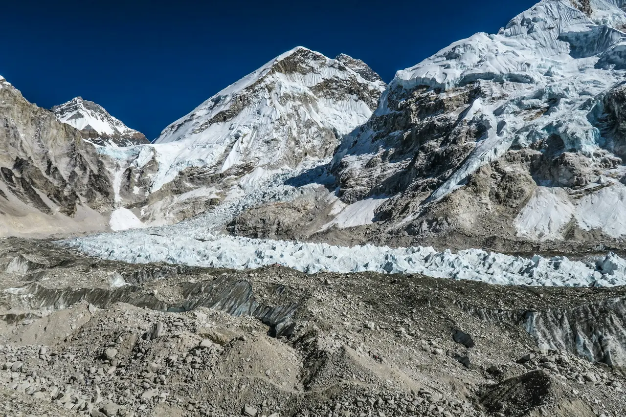
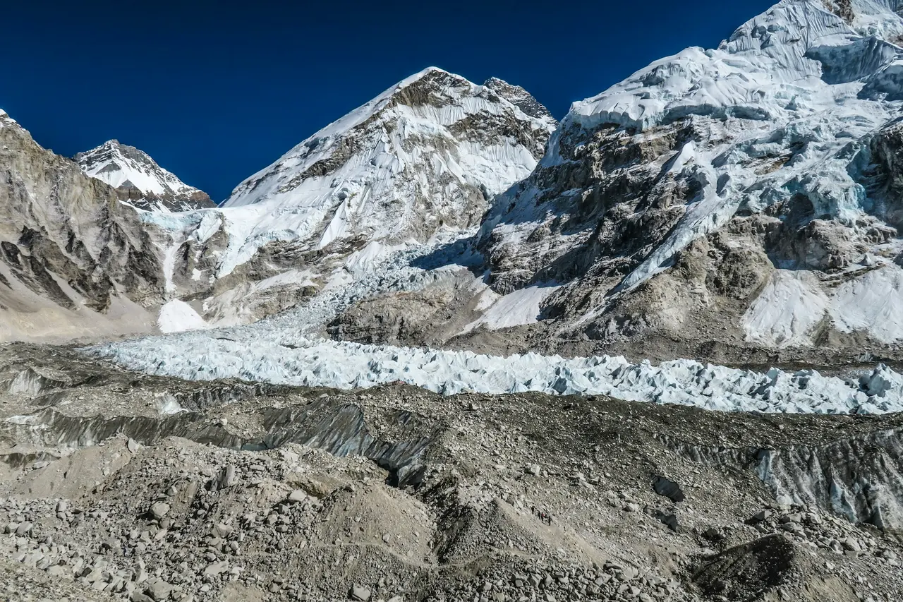
The Khumbu glacier, which trekkers cross on the approach to Everest Base Camp, is a debris-covered glacier whose surface looks like a chaotic field of rock and gravel rather than clean ice, because centuries of rockfall from the surrounding peaks have buried much of its lower reaches under a thick layer of moraine debris. This debris cover actually insulates the ice beneath it in places, slowing melt compared with clean, exposed glacier ice, but it does not stop the glacier's overall retreat and thinning, which has been documented over recent decades through repeat photography and satellite measurement.
Walking on and beside the Khumbu glacier means crossing genuinely unstable ground: the surface hides crevasses, the moraine ridges shift as underlying ice melts unevenly, and a network of meltwater ponds sits scattered across the glacier's lower section, some small and temporary, others persistent and slowly growing year on year. These ponds are a visible, walkable-past example of exactly the process that produces a dangerous glacial lake at a larger scale — a hollow in the ice or moraine fills with meltwater faster than it can drain, and the pond grows.
Trekking guides who lead the same Khumbu itinerary repeatedly are often the best source of what has visibly changed on this specific stretch of trail: a pond that has grown noticeably from one season to the next, or a section of trail rerouted because the moraine shifted under it, is the kind of change that shows up in a guide's memory before it shows up in any published survey. This is one of the more concrete, ground-level reasons the Everest Base Camp trek is not a static, unchanging route from one year to the next, even though the itinerary on paper looks identical season after season.
What a GLOF is
A glacial lake outburst flood, usually abbreviated GLOF, is a sudden, often catastrophic release of water when the natural dam holding back a glacial lake fails, sending a wall of water, mud and debris rapidly down the valley below. The dam involved is typically moraine — loose rock and sediment left behind by a retreating glacier — rather than solid bedrock, and moraine dams are inherently less stable than rock: they can be breached by an ice avalanche or rockfall striking the lake and displacing water over the dam, by the dam itself eroding as meltwater seeps through it, or by an earthquake shaking loose material into failure.
Nepal has documented GLOF events with real consequences. The Dig Tsho GLOF in 1985, triggered by an ice avalanche entering the lake, released an estimated several million cubic metres of water down the Bhote Koshi and Dudh Koshi valleys, destroying a nearly complete hydropower plant, bridges and farmland along the way, and it remains one of the most-studied GLOF events in the Himalaya precisely because of how well the triggering mechanism was documented afterwards. More recent events, including flooding associated with glacial lake activity in 2016 and subsequent years, have reinforced why specific lakes across the Everest and other high-mountain regions are now subject to ongoing monitoring rather than one-off assessment.
The danger a GLOF poses is not limited to the immediate area around the lake. Because the flood travels down an existing valley and river channel, it can affect villages, trails, bridges and infrastructure many kilometres downstream of the lake itself, arriving with little or no warning in a region without an established early-warning siren network at every vulnerable site.
The monitored lakes: Imja, Tsho Rolpa, Thulagi
Three Nepali glacial lakes are among the most frequently referenced in scientific and government risk assessments, each illustrating a different response to identified GLOF risk.
Imja Tsho, in the Khumbu region below Island Peak and near the main Everest Base Camp trekking corridor, is one of the fastest-growing glacial lakes in the Himalaya, having expanded substantially from a small collection of meltwater ponds in the mid-20th century into a large lake as the Imja and Lhotse Shar glaciers retreated. Its proximity to a heavily trekked and populated trail corridor, combined with its documented growth, has made it a priority site for engineered risk-reduction work, including a lake-lowering project completed in the 2010s intended to reduce the volume of water that could be released in a breach.
Tsho Rolpa, in the Rolwaling valley east of the Khumbu, is one of the largest and most studied glacial lakes in Nepal and has been the subject of active risk-mitigation engineering since the late 1990s, when an outlet channel and control structure were built specifically to lower the lake's water level and reduce the pressure on its moraine dam. It is frequently cited in Himalayan GLOF literature as an example of an early, large-scale mitigation project rather than a lake that has simply been left to grow unmonitored.
Thulagi, in the Manaslu region, is a large glacial lake fed by the Thulagi glacier and has also been identified in regional risk assessments as a lake warranting ongoing monitoring, given its size and its position above populated valleys and trekking routes on the Manaslu Circuit.
| Lake | Region | Notable feature |
|---|---|---|
| Imja Tsho | Khumbu, near Island Peak | Rapid growth since the mid-20th century; lake-lowering project completed 2010s |
| Tsho Rolpa | Rolwaling valley | One of Nepal's largest glacial lakes; outlet control structure built in the late 1990s |
| Thulagi | Manaslu region | Large lake above the Manaslu Circuit trekking route; ongoing monitoring |
 [PHOTO]
These three lakes do not represent the full list of lakes under monitoring in Nepal — regional and international scientific bodies maintain broader risk inventories covering dozens of additional lakes — but they are the three most consistently referenced in both scientific literature and trekking-region safety discussion, because each sits close to a well-travelled route or populated valley. Additional lakes in the Kanchenjunga and Langtang regions also appear in national risk inventories, though with lower public visibility than Imja Tsho and Tsho Rolpa simply because far fewer trekkers pass close enough to see them directly.
What the melt means for trekking routes
Glacier retreat and glacial lake growth have already changed specific Himalayan trekking routes, not just the scenery around them, and the changes tend to fall into three categories: rerouted trail sections, lost or replaced bridges, and shifting water sources.
Trail rerouting happens where a route that once crossed stable glacier ice or a firm moraine ridge becomes unsafe as the ice beneath it thins unevenly or the moraine slumps; guides and route-maintenance teams on popular treks periodically shift the marked trail by tens or hundreds of metres to avoid a section that has become unstable since the previous season. Bridge losses occur where a river fed by glacial meltwater rises, floods, or shifts its channel enough to undermine or wash out a crossing that was stable for years previously; this is a recurring maintenance cost on routes that cross multiple glacier-fed rivers, including sections of the Everest and Manaslu trails. Water source reliability is the least visible but most practically important change for trekkers: some lodges and villages that historically relied on a specific glacial meltwater stream have had to adjust as flow patterns shift with glacier retreat, affecting availability at certain times of year in specific locations.
None of this means popular routes are becoming unsafe overall — infrastructure and route management adapt, generally successfully, to gradual change — but it does mean that a fixed, unchanging mental picture of "the EBC trail" or "the Manaslu Circuit" from a guidebook printed several years ago can be measurably out of date on specific bridge and trail-section details, which is one more reason local, current route knowledge from an active guide matters more here than on lower-altitude treks with no glacial terrain to account for. This is also a useful, concrete illustration of a broader point about Nepal's geography: the High Himalaya zone is not a static backdrop to a trekking itinerary but an actively changing landscape, and glacial retreat is the clearest, most measurable example of that change on any popular route.
What trekkers can and can't see
A trekker walking the standard Everest Base Camp or Manaslu Circuit routes will see plenty of visible glacier evidence — moraine ridges, debris-covered ice, meltwater ponds, and in places the glacier's terminus itself — but will not see most of what actually determines GLOF risk at a given lake, because that requires measurement, not observation: dam width and composition, water depth and volume, and the rate of change over multiple seasons, all of which come from surveying and monitoring work rather than a single visit.
This gap matters for how trekkers should interpret what they see. A glacial lake that looks calm and picturesque from a trail viewpoint, such as Imja Tsho seen from a side trip near Chukhung, gives no visual indication of how close its moraine dam is to a critical threshold; that assessment comes from ongoing scientific monitoring, not from the view. Conversely, an obviously unstable-looking stretch of debris-covered glacier, such as much of the lower Khumbu glacier's crossing point, is generally well understood and actively managed by route-maintenance teams precisely because its instability is visible and expected, rather than hidden. Trekkers should treat visible drama and actual risk as two different things, and rely on official trail guidance, permit-office advisories and an experienced guide's current knowledge rather than personal visual judgement of a lake's safety.
FAQ
How many glaciers does Nepal have? Nepal has several thousand glaciers, collectively covering an estimated 3,900 km² of high-mountain terrain, concentrated mainly in the Everest, Annapurna, Langtang and Kanchenjunga regions. They range from small cirque glaciers to major valley glaciers many kilometres long.
What is a GLOF? A glacial lake outburst flood (GLOF) is a sudden release of water when the moraine dam holding back a glacial lake fails, sending a fast-moving flood of water, mud and debris down the valley below. Triggers include ice avalanches, rockfall, dam erosion and earthquakes.
Are Himalayan glaciers melting? Yes. Repeat photography and satellite monitoring have documented retreat and thinning across most of Nepal's glaciers in recent decades, including the Khumbu glacier that Everest Base Camp trekkers walk across. The pace varies by glacier and elevation, but the overall trend is retreat.
Is Everest Base Camp on a glacier? Yes. Everest Base Camp sits on the Khumbu glacier itself, on a section of moraine-covered ice near its base, which is why the camp's exact usable ground shifts slightly from season to season as the underlying ice moves and melts unevenly.
Trek this ground with a guide who reads it correctly
A guide who has crossed the Khumbu glacier dozens of times knows which moraine ridges have shifted since last season and which meltwater ponds are new — the kind of current, ground-level knowledge that no satellite survey or guidebook update delivers as fast as someone who was there two weeks ago. NepGem's guide profiles show each guide's specific route history and altitude record before you book, so you know whether the person leading you across this terrain has genuinely walked it recently. Hire the guide directly rather than trusting a route description alone, and you get real-time trail judgement on exactly the kind of shifting, glacier-dependent ground this article describes, at the moment it actually matters.


